
Make a donation
Gear up for your next adventure:
As an Amazon Associate, this site earns from qualifying purchases at no extra cost to you.
Bellechester topographic map
Click on the map to display elevation.
Make a donation
Gear up for your next adventure:
As an Amazon Associate, this site earns from qualifying purchases at no extra cost to you.
About this map
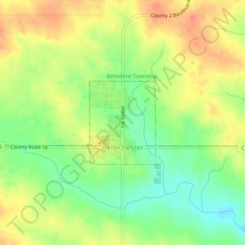
Name: Bellechester topographic map, elevation, terrain.
Location: Bellechester, Wabasha County, Minnesota, United States (44.36641 -92.51643 44.37560 -92.50621)
Average elevation: 1,122 ft
Minimum elevation: 1,033 ft
Maximum elevation: 1,201 ft
Wabasha County trails, hiking, mountain biking, running and outdoor activities
Make a donation
Gear up for your next adventure:
As an Amazon Associate, this site earns from qualifying purchases at no extra cost to you.
Other topographic maps
Click on a map to view its topography, its elevation and its terrain.
Upper Mississippi River National Wildlife & Fish Refuge - Weaver Landing
United States > Minnesota > Wabasha County > Weaver
Average elevation: 705 ft
Plainview
United States > Minnesota > Wabasha County > Plainview
Plainview was platted in 1857. The city was named from its location on a plain at a lofty elevation, where a "plain view" can be had of the surrounding area. A post office has been in operation at Plainview since 1857. Plainview was incorporated in 1875.
Average elevation: 1,142 ft