
Make a donation
Gear up for your next adventure:
As an Amazon Associate, this site earns from qualifying purchases at no extra cost to you.
Uhlenberg topographic map
Click on the map to display elevation.
Make a donation
Gear up for your next adventure:
As an Amazon Associate, this site earns from qualifying purchases at no extra cost to you.
About this map
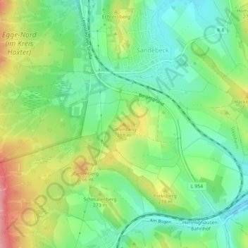
Name: Uhlenberg topographic map, elevation, terrain.
Average elevation: 814 ft
Minimum elevation: 669 ft
Maximum elevation: 1,047 ft
Make a donation
Gear up for your next adventure:
As an Amazon Associate, this site earns from qualifying purchases at no extra cost to you.
Other topographic maps
Click on a map to view its topography, its elevation and its terrain.
Egge-Nord (im Kreis Höxter)
Deutschland > Nordrhein-Westfalen > Kreis Höxter > Steinheim > Sandebeck
Average elevation: 991 ft
32839
Deutschland > Nordrhein-Westfalen > Kreis Höxter > Steinheim > Vinsebeck
Average elevation: 692 ft
Make a donation
Gear up for your next adventure:
As an Amazon Associate, this site earns from qualifying purchases at no extra cost to you.
Vinsebeck
Deutschland > Nordrhein-Westfalen > Kreis Höxter > Steinheim
Prägend für die Entwicklung von Vinsebeck waren die Herren und Freiherren von der Lippe, die 1720 das Wasserschloss als Familiensitz errichteten. Justus Wehmer aus Hildesheim ließ 1721 das Schloss im Spätbarock- bzw. Régance-Stil bauen. Im Siebenjährigen Krieg lagen 1761 11.000 Franzosen auf den Höhen…
Average elevation: 633 ft