Geolocate

Bulwandi topographic map

Click on the map to display elevation.

About this map

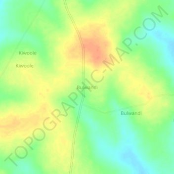
Name: Bulwandi topographic map, elevation, terrain.

Location: Bulwandi, Nakasongola, Central Region, Uganda (1.15425 32.72406 1.19425 32.76406)

Average elevation: 3,504 ft

Minimum elevation: 3,435 ft

Maximum elevation: 3,573 ft

Gear up for your next adventure:

🎒Gear Packing Cubes - Organize your backpack efficiently
🛏️Cold Weather Sleeping Bag - Warm sleeping bag for cold conditions
🩹Survival Bandages - High‑quality bandages for emergencies
🧯Portable Fire Pit - Compact fire pit for camping spots
🏕️Family Camping Gear - Essentials for group camping trips

As an Amazon Associate, this site earns from qualifying purchases at no extra cost to you.