
Make a donation
Gear up for your next adventure:
As an Amazon Associate, this site earns from qualifying purchases at no extra cost to you.
Cockermouth topographic map
Click on the map to display elevation.
Make a donation
Gear up for your next adventure:
As an Amazon Associate, this site earns from qualifying purchases at no extra cost to you.
Cockermouth
Cockermouth has a temperate climate that is influenced by the Irish Sea and its low-lying elevation. Cockermouth receives slightly below average rainfall compared with the UK average. Temperatures are also round about average compared with other parts of the UK. The nearest weather station for which online records are available is Aspatria, about 7 miles (11 kilometres) north-northeast of the town centre.
Make a donation
Gear up for your next adventure:
As an Amazon Associate, this site earns from qualifying purchases at no extra cost to you.
About this map
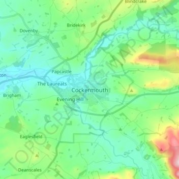
Name: Cockermouth topographic map, elevation, terrain.
Average elevation: 344 ft
Minimum elevation: 98 ft
Maximum elevation: 1,184 ft
Make a donation
Gear up for your next adventure:
As an Amazon Associate, this site earns from qualifying purchases at no extra cost to you.