
Khera Malla topographic map
Interactive map
Click on the map to display elevation.
About this map
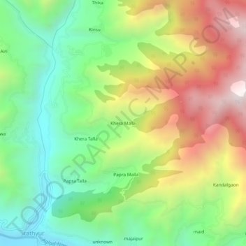
Name: Khera Malla topographic map, elevation, terrain.
Average elevation: 5,436 ft
Minimum elevation: 3,743 ft
Maximum elevation: 7,861 ft
Other topographic maps
Click on a map to view its topography, its elevation and its terrain.
Miyani
India > Uttarakhand > Dhanaulti
Miyani, Dhanaulti, Tehri Garhwal District, Uttarakhand, 249186, India
Average elevation: 4,918 ft
unknown
India > Uttarakhand > Dhanaulti
unknown, Dhanaulti, Tehri Garhwal, Uttarakhand, India
Average elevation: 6,467 ft
Khand
India > Uttarakhand > Dhanaulti > Ramolgaon
Khand, Ramolgaon, Dhanaulti, Tehri Garhwal, Uttarakhand, 249196, India
Average elevation: 3,386 ft
Jaidwar Talla
India > Uttarakhand > Dhanaulti > Jaidwar Talla
Jaidwar Talla, Dhanaulti, Tehri Garhwal, Uttarakhand, India
Average elevation: 4,902 ft