Geolocate

Salal topographic map

Click on the map to display elevation.

About this map

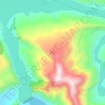
Name: Salal topographic map, elevation, terrain.

Location: Salal, Reasi, Reasi District, Jammu and Kashmir, India (33.14062 74.80132 33.18062 74.84132)

Average elevation: 2,178 ft

Minimum elevation: 1,302 ft

Maximum elevation: 3,730 ft

Gear up for your next adventure:

💧Water Purification System - Clean water on the trail with reliable purifiers
🛠️Backpacking Tool Kit - Essential toolkit for outdoor repairs
🪶Fire Starter Kit - Reliable fire starter for survival and camping
🌡️Portable Weather Meter - Track weather conditions on the trail
🔋Solar Power Banks - Keep your GPS and phone charged in remote wilderness areas

As an Amazon Associate, this site earns from qualifying purchases at no extra cost to you.