
Wittenberg topographic map
Click on the map to display elevation.
About this map
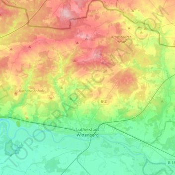
Name: Wittenberg topographic map, elevation, terrain.
Location: Wittenberg, Saxony-Anhalt, Germany (51.81868 12.48492 52.01333 12.77674)
Average elevation: 354 ft
Minimum elevation: 180 ft
Maximum elevation: 623 ft
Other topographic maps
Click on a map to view its topography, its elevation and its terrain.
Lutherstadt Wittenberg
Germany > Saxony-Anhalt > Wittenberg > Wittenberg > Lutherstadt Wittenberg
Average elevation: 259 ft