
Airão (São João Batista) topographic map
Interactive map
Click on the map to display elevation.
About this map
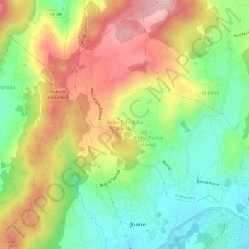
Name: Airão (São João Batista) topographic map, elevation, terrain.
Location: Airão (São João Batista), Guimarães, Braga, 4805, Portugal (41.43541 -8.44003 41.47541 -8.40003)
Average elevation: 883 ft
Minimum elevation: 413 ft
Maximum elevation: 1,476 ft
Other topographic maps
Click on a map to view its topography, its elevation and its terrain.
Nespereira
Nespereira, Guimarães, Braga, 4811-909, Portugal
Average elevation: 794 ft
Polvoreira
Polvoreira, Guimarães, Braga, Portugal
Average elevation: 820 ft
Prazins (Santa Eufémia)
Portugal > Braga > Guimarães > Prazins (Santa Eufémia)
Prazins (Santa Eufémia), Guimarães, Braga, Portugal
Average elevation: 548 ft