
Lordelo topographic map
Interactive map
Click on the map to display elevation.
About this map
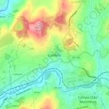
Name: Lordelo topographic map, elevation, terrain.
Location: Lordelo, Guimarães, Braga, 4815-182, Portugal (41.36199 -8.39564 41.38344 -8.35504)
Average elevation: 469 ft
Minimum elevation: 249 ft
Maximum elevation: 837 ft
Other topographic maps
Click on a map to view its topography, its elevation and its terrain.
Mascotelos
Mascotelos, Candoso São Tiago e Mascotelos, Guimarães, Braga, 4835-140, Portugal
Average elevation: 673 ft
Airão (São João Batista)
Airão (São João Batista), Guimarães, Braga, 4805, Portugal
Average elevation: 883 ft
Nespereira
Nespereira, Guimarães, Braga, 4811-909, Portugal
Average elevation: 794 ft
Polvoreira
Polvoreira, Guimarães, Braga, Portugal
Average elevation: 820 ft
Prazins (Santa Eufémia)
Portugal > Braga > Guimarães > Prazins (Santa Eufémia)
Prazins (Santa Eufémia), Guimarães, Braga, Portugal
Average elevation: 548 ft