
Bayard topographic map
Interactive map
Click on the map to display elevation.
About this map
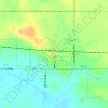
Name: Bayard topographic map, elevation, terrain.
Location: Bayard, Guthrie County, Iowa, United States (41.84750 -94.56626 41.85744 -94.55067)
Average elevation: 1,125 ft
Minimum elevation: 1,076 ft
Maximum elevation: 1,188 ft
Other topographic maps
Click on a map to view its topography, its elevation and its terrain.
Panora
United States > Iowa > Guthrie County
Panora, Guthrie County, Iowa, United States
Average elevation: 1,073 ft
Bagley
United States > Iowa > Guthrie County
Bagley, Guthrie County, Iowa, United States
Average elevation: 1,099 ft
Menlo
United States > Iowa > Guthrie County
Menlo, Guthrie County, Iowa, 50164, United States
Average elevation: 1,240 ft
City of Coon Rapids
United States > Iowa > Guthrie County
City of Coon Rapids, Guthrie County, Iowa, United States
Average elevation: 1,106 ft
Adair/Finnegan Dam
United States > Iowa > Guthrie County
Adair/Finnegan Dam, Guthrie County, Iowa, United States
Average elevation: 1,138 ft
Jamaica
United States > Iowa > Guthrie County
Jamaica, Guthrie County, Iowa, United States
Average elevation: 1,040 ft
Guthrie Center
United States > Iowa > Guthrie County
Guthrie Center, Guthrie County, Iowa, United States
Average elevation: 1,138 ft
Lake Panorama
United States > Iowa > Guthrie County
Lake Panorama, Guthrie County, Iowa, United States
Average elevation: 1,142 ft
City of Coon Rapids
United States > Iowa > Guthrie County
City of Coon Rapids, Guthrie County, Iowa, United States
Average elevation: 1,132 ft
Yale
United States > Iowa > Guthrie County
Yale, Guthrie County, Iowa, United States
Average elevation: 1,109 ft
Casey
United States > Iowa > Guthrie County
Casey, Guthrie County, Iowa, United States
Average elevation: 1,276 ft