
Make a donation
Gear up for your next adventure:
As an Amazon Associate, this site earns from qualifying purchases at no extra cost to you.
Adair/Finnegan Dam topographic map
Click on the map to display elevation.
Make a donation
Gear up for your next adventure:
As an Amazon Associate, this site earns from qualifying purchases at no extra cost to you.
About this map
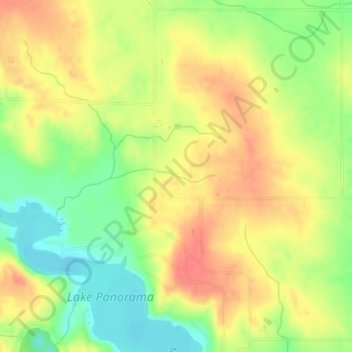
Name: Adair/Finnegan Dam topographic map, elevation, terrain.
Location: Adair/Finnegan Dam, Guthrie County, Iowa, United States (41.74712 -94.43282 41.74722 -94.43272)
Average elevation: 1,138 ft
Minimum elevation: 1,033 ft
Maximum elevation: 1,220 ft
Guthrie County trails, hiking, mountain biking, running and outdoor activities
Make a donation
Gear up for your next adventure:
As an Amazon Associate, this site earns from qualifying purchases at no extra cost to you.
Other topographic maps
Click on a map to view its topography, its elevation and its terrain.
Make a donation
Gear up for your next adventure:
As an Amazon Associate, this site earns from qualifying purchases at no extra cost to you.