
Make a donation
Gear up for your next adventure:
As an Amazon Associate, this site earns from qualifying purchases at no extra cost to you.
Weiße Elster topographic map
Click on the map to display elevation.
Make a donation
Gear up for your next adventure:
As an Amazon Associate, this site earns from qualifying purchases at no extra cost to you.
Weiße Elster
Sie entspringt in Tschechien im Elstergebirge östlich von Aš (Asch), etwa einen Kilometer Luftlinie entfernt von der deutsch-tschechischen Grenze (westlich des Grenzsteines 5/18) bei Bärendorf, unweit des Dorfes Výhledy (Steingrün). Sie fließt durch die Städte Plauen, Gera sowie Leipzig und mündet im Süden des halleschen Stadtteils Silberhöhe in die Saale.
Make a donation
Gear up for your next adventure:
As an Amazon Associate, this site earns from qualifying purchases at no extra cost to you.
About this map
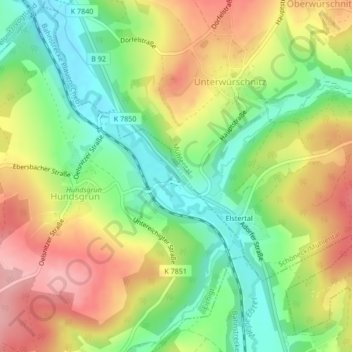
Name: Weiße Elster topographic map, elevation, terrain.
Average elevation: 1,535 ft
Minimum elevation: 1,325 ft
Maximum elevation: 1,772 ft
Make a donation
Gear up for your next adventure:
As an Amazon Associate, this site earns from qualifying purchases at no extra cost to you.