
Puerto Carreño topographic map
Interactive map
Click on the map to display elevation.
About this map
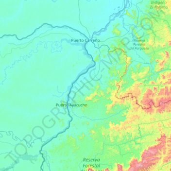
Name: Puerto Carreño topographic map, elevation, terrain.
Location: Puerto Carreño, Vichada, Colombia (5.30179 -68.82483 6.32432 -67.40344)
Average elevation: 633 ft
Minimum elevation: 105 ft
Maximum elevation: 5,177 ft
Other topographic maps
Click on a map to view its topography, its elevation and its terrain.
Puerto Carreño
Colombia > Vichada > Puerto Carreño
Puerto Carreño, Vichada, 990001-990017, Colombia
Average elevation: 151 ft