
Make a donation
Gear up for your next adventure:
As an Amazon Associate, this site earns from qualifying purchases at no extra cost to you.
Puerto Carreño topographic map
Click on the map to display elevation.
Make a donation
Gear up for your next adventure:
As an Amazon Associate, this site earns from qualifying purchases at no extra cost to you.
Puerto Carreño
The area of the municipality is within the llanos plains which cover large areas in Colombia and Venezuela that are rich in biodiversity. Geologically the municipality of Puerto Carreño lies on the Guiana Shield mostly made up by Cenozoic and Precambric formations, with some low altitude mountains such as the Mounts of Casuarito and the Hormiga and Guaripa mountains.
Make a donation
Gear up for your next adventure:
As an Amazon Associate, this site earns from qualifying purchases at no extra cost to you.
About this map
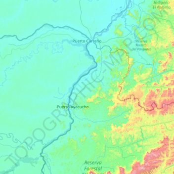
Name: Puerto Carreño topographic map, elevation, terrain.
Location: Puerto Carreño, Vichada, Colombia (5.30179 -68.82483 6.32432 -67.40344)
Average elevation: 633 ft
Minimum elevation: 105 ft
Maximum elevation: 5,177 ft
Make a donation
Gear up for your next adventure:
As an Amazon Associate, this site earns from qualifying purchases at no extra cost to you.