Geolocate

Cataula topographic map

Click on the map to display elevation.

About this map

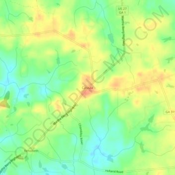
Name: Cataula topographic map, elevation, terrain.

Location: Cataula, Harris County, Georgia, 31804, United States (32.63541 -84.88854 32.67541 -84.84854)

Average elevation: 646 ft

Minimum elevation: 571 ft

Maximum elevation: 722 ft

Harris County trails, hiking, mountain biking, running and outdoor activities

Other topographic maps

Click on a map to view its topography, its elevation and its terrain.

Hamilton

United States > Georgia > Harris County

Average elevation: 810 ft

Shiloh

United States > Georgia > Harris County

Average elevation: 866 ft

Waverly Hall

United States > Georgia > Harris County

Average elevation: 712 ft

Whitesville

United States > Georgia > Harris County

Average elevation: 682 ft

Pine Mountain

United States > Georgia > Harris County

Average elevation: 899 ft

Gear up for your next adventure:

🧭Hiking Compass - Precision compass for reliable navigation in the wilderness
📻Weather Alert Radios - Stay informed of storm risks while off-the-grid
🦟Ultrasonic Repellers - Create a bug-free zone at your camp or rest stop
🔊Portable Camp Speaker - Music and alerts at camp
🛠️Outdoor Gear Repair Kit - Essential tools to fix gear on the trail

As an Amazon Associate, this site earns from qualifying purchases at no extra cost to you.