Geolocate

Tuble topographic map

Click on the map to display elevation.

About this map

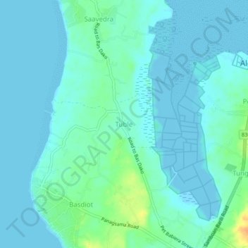
Name: Tuble topographic map, elevation, terrain.

Location: Tuble, Moalboal, Cebu, Central Visayas, 6032, Philippines (9.94040 123.36099 9.98040 123.40099)

Average elevation: 20 ft

Minimum elevation: -10 ft

Maximum elevation: 108 ft

Other topographic maps

Click on a map to view its topography, its elevation and its terrain.

Moalboal

Philippines > Cebu > Moalboal

Average elevation: 43 ft

Gear up for your next adventure:

🚗GPS Dash Cams - Record your scenic drives through mountain passes and canyons
🔌Solar Panel Charger - Charge gear sustainably outdoors
🔭Compact Binoculars - HD vision for scouting terrain and identifying distant landmarks
Backpacking Tents - Weight-optimized shelters for multi-day topographic surveys
🧥Waterproof Jacket for Hiking - Breathable and rugged rain jacket for outdoor excursions

As an Amazon Associate, this site earns from qualifying purchases at no extra cost to you.