
Make a donation
Gear up for your next adventure:
As an Amazon Associate, this site earns from qualifying purchases at no extra cost to you.
Turkey Mountain topographic map
Click on the map to display elevation.
Make a donation
Gear up for your next adventure:
As an Amazon Associate, this site earns from qualifying purchases at no extra cost to you.
About this map
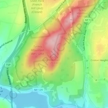
Name: Turkey Mountain topographic map, elevation, terrain.
Average elevation: 466 ft
Minimum elevation: 213 ft
Maximum elevation: 817 ft
Make a donation
Gear up for your next adventure:
As an Amazon Associate, this site earns from qualifying purchases at no extra cost to you.
Other topographic maps
Click on a map to view its topography, its elevation and its terrain.
Yorktown Heights
United States > New York > Westchester County > Town of Yorktown > Yorktown Heights
Average elevation: 522 ft
Shrub Oak
United States > New York > Westchester County > Town of Yorktown > Shrub Oak
Average elevation: 512 ft
Shrub Oak
United States > New York > Westchester County > Town of Yorktown > Shrub Oak
Average elevation: 512 ft
Lake Mohegan
United States > New York > Westchester County > Town of Yorktown
Average elevation: 459 ft
Make a donation
Gear up for your next adventure:
As an Amazon Associate, this site earns from qualifying purchases at no extra cost to you.
Yorktown Heights
United States > New York > Westchester County > Town of Yorktown > Yorktown Heights
Average elevation: 522 ft