
Make a donation
Gear up for your next adventure:
As an Amazon Associate, this site earns from qualifying purchases at no extra cost to you.
Morro Santa Terezinha topographic map
Click on the map to display elevation.
Make a donation
Gear up for your next adventure:
As an Amazon Associate, this site earns from qualifying purchases at no extra cost to you.
About this map
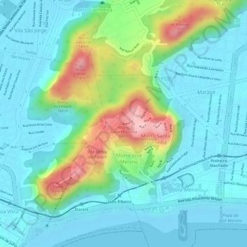
Name: Morro Santa Terezinha topographic map, elevation, terrain.
Average elevation: 154 ft
Minimum elevation: -10 ft
Maximum elevation: 627 ft
Make a donation
Gear up for your next adventure:
As an Amazon Associate, this site earns from qualifying purchases at no extra cost to you.
Other topographic maps
Click on a map to view its topography, its elevation and its terrain.
Centro
Brasil > São Paulo > Região Metropolitana da Baixada Santista > Santos
Average elevation: 46 ft
Praça da santa
Brasil > São Paulo > Região Metropolitana da Baixada Santista > Santos
Average elevation: 115 ft
Embaré
Brasil > São Paulo > Região Metropolitana da Baixada Santista > Santos
Average elevation: 23 ft
Praça Doutor Caio Ribeiro de Moraes e Silva
Brasil > São Paulo > Região Metropolitana da Baixada Santista > Santos
Average elevation: 20 ft
Make a donation
Gear up for your next adventure:
As an Amazon Associate, this site earns from qualifying purchases at no extra cost to you.
Estuário de Santos
Brasil > São Paulo > Região Metropolitana da Baixada Santista > Santos
Average elevation: 33 ft
Praia da Aparecida
Brasil > São Paulo > Região Metropolitana da Baixada Santista > Santos
Average elevation: 16 ft
Rio Diana
Brasil > São Paulo > Região Metropolitana da Baixada Santista > Santos
Average elevation: 7 ft
Ponta da Praia
Brasil > São Paulo > Região Metropolitana da Baixada Santista > Santos
Average elevation: 16 ft
Make a donation
Gear up for your next adventure:
As an Amazon Associate, this site earns from qualifying purchases at no extra cost to you.
Ponta da Praia
Brasil > São Paulo > Região Metropolitana da Baixada Santista > Santos
Average elevation: 16 ft