
Putumajore/Pozzomaggiore topographic map
Interactive map
Click on the map to display elevation.
About this map
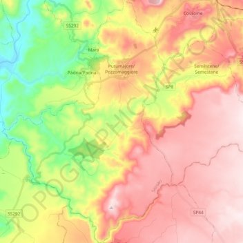
Name: Putumajore/Pozzomaggiore topographic map, elevation, terrain.
Location: Putumajore/Pozzomaggiore, Sassari, Sardinia, 07018, Italy (40.29688 8.56882 40.43841 8.69901)
Average elevation: 1,348 ft
Minimum elevation: 423 ft
Maximum elevation: 2,156 ft
Other topographic maps
Click on a map to view its topography, its elevation and its terrain.