
Make a donation
Gear up for your next adventure:
As an Amazon Associate, this site earns from qualifying purchases at no extra cost to you.
Bollacín topographic map
Click on the map to display elevation.
Make a donation
Gear up for your next adventure:
As an Amazon Associate, this site earns from qualifying purchases at no extra cost to you.
Bollacín
Bollacín es una localidad del municipio de Luena (Cantabria, España). En el año 2012 contaba con una población de 80 habitantes (INE). La localidad se encuentra a 664 metros de altitud sobre el nivel del mar, y a 2,5 kilómetros de la capital municipal, San Miguel de Luena.
Make a donation
Gear up for your next adventure:
As an Amazon Associate, this site earns from qualifying purchases at no extra cost to you.
About this map
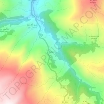
Name: Bollacín topographic map, elevation, terrain.
Location: Bollacín, San Miguel de Luena, Luena, Cantabria, 39681, España (43.06468 -3.91166 43.10468 -3.87166)
Average elevation: 2,320 ft
Minimum elevation: 1,161 ft
Maximum elevation: 3,835 ft
Make a donation
Gear up for your next adventure:
As an Amazon Associate, this site earns from qualifying purchases at no extra cost to you.