Geolocate

Elanora topographic map

Click on the map to display elevation.

About this map

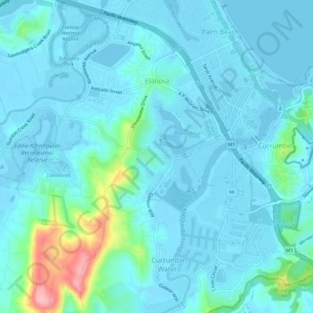
Name: Elanora topographic map, elevation, terrain.

Location: Elanora, Gold Coast City, Queensland, Australia (-28.16282 153.43172 -28.11455 153.47122)

Average elevation: 66 ft

Minimum elevation: -30 ft

Maximum elevation: 479 ft

Other topographic maps

Click on a map to view its topography, its elevation and its terrain.

Coomera Island

Australia > Queensland > Gold Coast City

Average elevation: 10 ft

Canyon Lookout

Australia > Queensland > Gold Coast City

Average elevation: 2,356 ft

Gear up for your next adventure:

🪑Ultralight Camp Chairs - Portable seating for resting after a long day of mapping
🍳Camping Cook Set - Complete cookware for outdoor meals
🛡️Bear Spray Outdoor - Protection in bear country hikes
🧭GPS Watch Accessories - Bands and chargers for GPS watches
📡GPS Antenna Upgrade - Enhance GPS reception in remote terrain

As an Amazon Associate, this site earns from qualifying purchases at no extra cost to you.