Geolocate

Petra topographic map

Click on the map to display elevation.

About this map

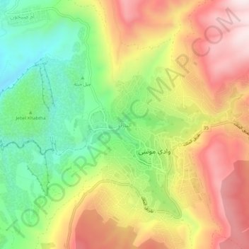
Name: Petra topographic map, elevation, terrain.

Location: Petra, Petra Sub-District, Petra District, Maan, 71810, Jordan (30.30584 35.45457 30.34584 35.49457)

Average elevation: 3,930 ft

Minimum elevation: 2,949 ft

Maximum elevation: 4,980 ft

Gear up for your next adventure:

📻Weather Alert Radios - Stay informed of storm risks while off-the-grid
🌲Outdoor Survival Books - Best books on survival skills
🪄Magnetic Compass - Accurate compass for navigation
📖Nature Tracking Books - Learn to track wildlife and terrain
🎒Trail Energy Bars - High‑calorie bars for hiking energy

As an Amazon Associate, this site earns from qualifying purchases at no extra cost to you.