
Make a donation
Gear up for your next adventure:
As an Amazon Associate, this site earns from qualifying purchases at no extra cost to you.
Karpacz topographic map
Click on the map to display elevation.
Make a donation
Gear up for your next adventure:
As an Amazon Associate, this site earns from qualifying purchases at no extra cost to you.
Karpacz
The first settlements in the area of Karpacz are noted by the official website of the city as being of probable Celtic origin and date to the 4th or 3rd century BC when they inhabited the region as part of gold-digging taking place in the area. The area was part of medieval Poland, after the establishment of the state in the 10th century. In the early 12th century the area was generally uninhabited, as mentioned in the oldest Polish chronicle Gesta principum Polonorum. The first mention of permanent location within the current boundaries of the town is dated to the beginning of 15th century and connected to the destruction of a village called Broniów, whose inhabitants moved to settle the area currently located at the altitude of the town's railway station.
Make a donation
Gear up for your next adventure:
As an Amazon Associate, this site earns from qualifying purchases at no extra cost to you.
About this map
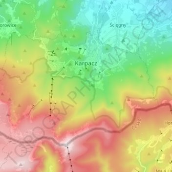
Name: Karpacz topographic map, elevation, terrain.
Average elevation: 2,995 ft
Minimum elevation: 1,385 ft
Maximum elevation: 5,236 ft
Make a donation
Gear up for your next adventure:
As an Amazon Associate, this site earns from qualifying purchases at no extra cost to you.