
Make a donation
Gear up for your next adventure:
As an Amazon Associate, this site earns from qualifying purchases at no extra cost to you.
Cleebronn topographic map
Click on the map to display elevation.
Make a donation
Gear up for your next adventure:
As an Amazon Associate, this site earns from qualifying purchases at no extra cost to you.
Cleebronn
Cleebronn is in the Zabergäu in the south of the district of Heilbronn, directly in the north of the Stromberg mountain with an elevation of 220 to 260 metres (720 to 850 ft). The landscape is characterised by wine-growing. The symbol of the municipality and the whole Zabergäu is the Michaelsberg, which has an elevation of 394 metres (1,293 ft).
Make a donation
Gear up for your next adventure:
As an Amazon Associate, this site earns from qualifying purchases at no extra cost to you.
About this map
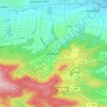
Name: Cleebronn topographic map, elevation, terrain.
Average elevation: 906 ft
Minimum elevation: 591 ft
Maximum elevation: 1,512 ft
Make a donation
Gear up for your next adventure:
As an Amazon Associate, this site earns from qualifying purchases at no extra cost to you.
Other topographic maps
Click on a map to view its topography, its elevation and its terrain.
Obereisesheim
Germany > Baden-Württemberg > Landkreis Heilbronn > Neckarsulm
Average elevation: 571 ft
Farnersberg
Germany > Baden-Württemberg > Landkreis Heilbronn > Beilstein > Farnersberg
Average elevation: 1,207 ft
Make a donation
Gear up for your next adventure:
As an Amazon Associate, this site earns from qualifying purchases at no extra cost to you.
Lampoldshausen
Germany > Baden-Württemberg > Landkreis Heilbronn > Hardthausen am Kocher > Lampoldshausen
Average elevation: 863 ft