
Make a donation
Gear up for your next adventure:
As an Amazon Associate, this site earns from qualifying purchases at no extra cost to you.
Hirschhof topographic map
Click on the map to display elevation.
Make a donation
Gear up for your next adventure:
As an Amazon Associate, this site earns from qualifying purchases at no extra cost to you.
About this map
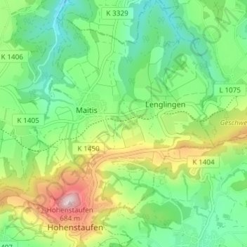
Name: Hirschhof topographic map, elevation, terrain.
Average elevation: 1,447 ft
Minimum elevation: 1,066 ft
Maximum elevation: 2,188 ft
Make a donation
Gear up for your next adventure:
As an Amazon Associate, this site earns from qualifying purchases at no extra cost to you.
Other topographic maps
Click on a map to view its topography, its elevation and its terrain.
Bartenbach
Deutschland > Baden-Württemberg > Landkreis Göppingen > Göppingen
Average elevation: 1,283 ft
Hohenstaufen
Deutschland > Baden-Württemberg > Landkreis Göppingen > Göppingen
Average elevation: 1,450 ft
Faurndau
Deutschland > Baden-Württemberg > Landkreis Göppingen > Göppingen
Average elevation: 1,138 ft
Make a donation
Gear up for your next adventure:
As an Amazon Associate, this site earns from qualifying purchases at no extra cost to you.
Holzheim
Deutschland > Baden-Württemberg > Landkreis Göppingen > Göppingen
Average elevation: 1,207 ft