
Make a donation
Gear up for your next adventure:
As an Amazon Associate, this site earns from qualifying purchases at no extra cost to you.
Ain Sefra topographic map
Click on the map to display elevation.
Make a donation
Gear up for your next adventure:
As an Amazon Associate, this site earns from qualifying purchases at no extra cost to you.
Ain Sefra
Aïn Séfra has a cold arid climate (Köppen BWk) with hot to sweltering summers and, owing to its elevation, cool to relatively cold winters, despite its location in the Sahara Desert.
Make a donation
Gear up for your next adventure:
As an Amazon Associate, this site earns from qualifying purchases at no extra cost to you.
About this map
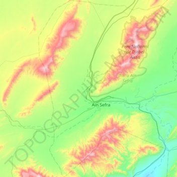
Name: Ain Sefra topographic map, elevation, terrain.
Location: Ain Sefra, Aïn Séfra District, Naâma, 45200, Algeria (32.56876 -0.77096 33.02796 -0.38731)
Average elevation: 4,222 ft
Minimum elevation: 2,940 ft
Maximum elevation: 7,323 ft
Make a donation
Gear up for your next adventure:
As an Amazon Associate, this site earns from qualifying purchases at no extra cost to you.