
Melaque topographic map
Interactive map
Click on the map to display elevation.
About this map
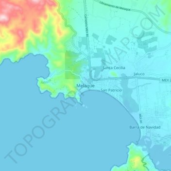
Name: Melaque topographic map, elevation, terrain.
Location: Melaque, Cihuatlán, Jalisco, 48985, México (19.18510 -104.75154 19.26510 -104.67154)
Average elevation: 125 ft
Minimum elevation: -7 ft
Maximum elevation: 1,115 ft
Other topographic maps
Click on a map to view its topography, its elevation and its terrain.
Barra de Navidad
Barra de Navidad, Cihuatlán, Jalisco, 48987, México
Average elevation: 39 ft