
Make a donation
Gear up for your next adventure:
As an Amazon Associate, this site earns from qualifying purchases at no extra cost to you.
Mells Park topographic map
Click on the map to display elevation.
Make a donation
Gear up for your next adventure:
As an Amazon Associate, this site earns from qualifying purchases at no extra cost to you.
Mells Park
The architect Edwin Lutyens had known the Horners, and Mells Park, since 1896. In 1918 he unsuccessfully tried to persuade the Horners to rebuild Park House. However, Reginald McKenna, the chairman of Midland Bank, and formerly Home Secretary and Chancellor of the Exchequer under Asquith, was married to Pamela Jekyll, the niece of Frances Horner. In 1924, the Horners agreed to let Mells Park to them for a nominal rent, on the understanding that the McKennas would rebuild the house. The McKennas had commissioned Lutyens before, in 1911, to build their town house, Mulberry House, at 36 Smith Square, London. Lutyens rebuilt Park House in neoclassical style in 1925. He built a two-storey, hip-roofed house in Bath stone, on the outline of the previous building, and joined it onto the surviving arcaded service court. The new main range has seven bays along the south and north elevations and four along each side, with Doric pilasters.
Make a donation
Gear up for your next adventure:
As an Amazon Associate, this site earns from qualifying purchases at no extra cost to you.
About this map
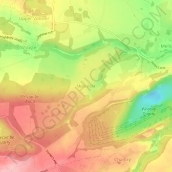
Name: Mells Park topographic map, elevation, terrain.
Location: Mells Park, Mells, Vobster, Somerset, England, United Kingdom (51.22676 -2.42467 51.24068 -2.39878)
Average elevation: 440 ft
Minimum elevation: 141 ft
Maximum elevation: 653 ft
Make a donation
Gear up for your next adventure:
As an Amazon Associate, this site earns from qualifying purchases at no extra cost to you.