
Thank you for supporting this site ❤️
Make a donation
Make a donation
Gear up for your next adventure:
As an Amazon Associate, this site earns from qualifying purchases at no extra cost to you.
Huajialing topographic map
Click on the map to display elevation.
Thank you for supporting this site ❤️
Make a donation
Make a donation
Gear up for your next adventure:
As an Amazon Associate, this site earns from qualifying purchases at no extra cost to you.
About this map
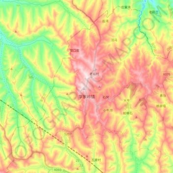
Name: Huajialing topographic map, elevation, terrain.
Location: Huajialing, Tongwei County, Dingxi City, Gansu, China (35.31684 104.95677 35.45886 105.14298)
Average elevation: 7,264 ft
Minimum elevation: 6,480 ft
Maximum elevation: 8,051 ft
Thank you for supporting this site ❤️
Make a donation
Make a donation
Gear up for your next adventure:
As an Amazon Associate, this site earns from qualifying purchases at no extra cost to you.