
Make a donation
Gear up for your next adventure:
As an Amazon Associate, this site earns from qualifying purchases at no extra cost to you.
Mönch topographic map
Click on the map to display elevation.
Make a donation
Gear up for your next adventure:
As an Amazon Associate, this site earns from qualifying purchases at no extra cost to you.
About this map
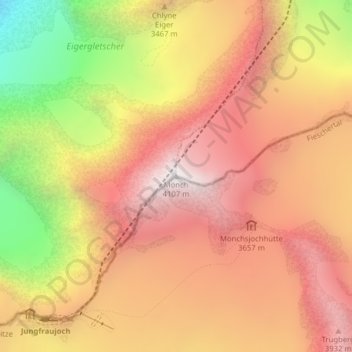
Name: Mönch topographic map, elevation, terrain.
Location: Mönch, Fieschertal, Conches, Valais, 3801, Suisse (46.55845 7.99722 46.55855 7.99732)
Average elevation: 11,129 ft
Minimum elevation: 7,602 ft
Maximum elevation: 13,399 ft
Make a donation
Gear up for your next adventure:
As an Amazon Associate, this site earns from qualifying purchases at no extra cost to you.
Other topographic maps
Click on a map to view its topography, its elevation and its terrain.
Glacier d'Aletsch
Suisse > Valais > Conches > Fieschertal
Sa longueur est de 23,6 kilomètres (en décembre 2001) pour une superficie de 117,6 km2 (ou 128 km2 selon la commission d'évaluation de l'Unesco) et une masse de 27 milliards de tonnes de glace,. Sa partie médiane avance à une vitesse de l'ordre de 180 à 200 mètres par an. Neuf sommets qui l'entourent…
Average elevation: 8,307 ft