
Thank you for supporting this site ❤️
Make a donation
Make a donation
Gear up for your next adventure:
As an Amazon Associate, this site earns from qualifying purchases at no extra cost to you.
Botteng topographic map
Click on the map to display elevation.
Thank you for supporting this site ❤️
Make a donation
Make a donation
Gear up for your next adventure:
As an Amazon Associate, this site earns from qualifying purchases at no extra cost to you.
About this map
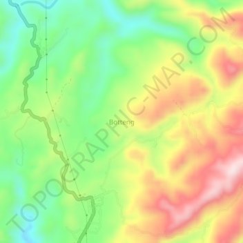
Name: Botteng topographic map, elevation, terrain.
Location: Botteng, Mamuju, West Sulawesi, Sulawesi, Indonesia (-2.78414 118.84896 -2.74414 118.88896)
Average elevation: 846 ft
Minimum elevation: 279 ft
Maximum elevation: 1,539 ft
Thank you for supporting this site ❤️
Make a donation
Make a donation
Gear up for your next adventure:
As an Amazon Associate, this site earns from qualifying purchases at no extra cost to you.