
Thank you for supporting this site ❤️
Make a donation
Make a donation
Gear up for your next adventure:
As an Amazon Associate, this site earns from qualifying purchases at no extra cost to you.
Kemlitz topographic map
Click on the map to display elevation.
Thank you for supporting this site ❤️
Make a donation
Make a donation
Gear up for your next adventure:
As an Amazon Associate, this site earns from qualifying purchases at no extra cost to you.
About this map
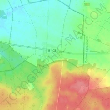
Name: Kemlitz topographic map, elevation, terrain.
Location: Kemlitz, Dahme/Mark, Teltow-Fläming, Brandenburg, Deutschland (51.82858 13.51085 51.86858 13.55085)
Average elevation: 394 ft
Minimum elevation: 305 ft
Maximum elevation: 528 ft
Thank you for supporting this site ❤️
Make a donation
Make a donation
Gear up for your next adventure:
As an Amazon Associate, this site earns from qualifying purchases at no extra cost to you.
Other topographic maps
Click on a map to view its topography, its elevation and its terrain.