
Thank you for supporting this site ❤️
Make a donation
Make a donation
Gear up for your next adventure:
As an Amazon Associate, this site earns from qualifying purchases at no extra cost to you.
Azro topographic map
Click on the map to display elevation.
Thank you for supporting this site ❤️
Make a donation
Make a donation
Gear up for your next adventure:
As an Amazon Associate, this site earns from qualifying purchases at no extra cost to you.
About this map
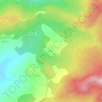
Name: Azro topographic map, elevation, terrain.
Location: Azro, Chebel, Yakouren, Daïra Azazga, Tizi Ouzou, Algérie (36.68814 4.44526 36.72814 4.48526)
Average elevation: 2,887 ft
Minimum elevation: 2,001 ft
Maximum elevation: 4,035 ft
Thank you for supporting this site ❤️
Make a donation
Make a donation
Gear up for your next adventure:
As an Amazon Associate, this site earns from qualifying purchases at no extra cost to you.