
Thank you for supporting this site ❤️
Make a donation
Make a donation
Gear up for your next adventure:
As an Amazon Associate, this site earns from qualifying purchases at no extra cost to you.
Almorox topographic map
Click on the map to display elevation.
Thank you for supporting this site ❤️
Make a donation
Make a donation
Gear up for your next adventure:
As an Amazon Associate, this site earns from qualifying purchases at no extra cost to you.
About this map
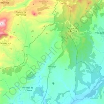
Name: Almorox topographic map, elevation, terrain.
Location: Almorox, Torrijos, Toledo, Castile-La Mancha, Spain (40.18516 -4.43745 40.31834 -4.34521)
Average elevation: 2,021 ft
Minimum elevation: 1,391 ft
Maximum elevation: 3,921 ft
Thank you for supporting this site ❤️
Make a donation
Make a donation
Gear up for your next adventure:
As an Amazon Associate, this site earns from qualifying purchases at no extra cost to you.