
Make a donation
Gear up for your next adventure:
As an Amazon Associate, this site earns from qualifying purchases at no extra cost to you.
L'Ermitage topographic map
Click on the map to display elevation.
Make a donation
Gear up for your next adventure:
As an Amazon Associate, this site earns from qualifying purchases at no extra cost to you.
L'Ermitage
Avant d’être un lieu de loisirs pour les êtres humains, la plage de L’Hermitage est un biotope à part entière où vivent notamment des « crabes-fantômes » du genre Ocypode (O. pallidula et O. ceratophtalmus). On peut les voir creusant leur terrier en lisière de l’eau à chaque marée descendante, ou se nourrir de déchets organiques divers dans les laisses de mer. Ils se précipitent dans leur trou à grande vitesse à l’approche des promeneurs pour en ressortir quelques instants plus tard. On peut rencontrer un bernard-l’ermite terrestre (Coenobita rugosus) venant lui aussi profiter des laisses de mer, parmi lesquelles arrivent parfois des Sargasses venues de loin et pouvant transporter un grand voyageur de petite taille, le crabe Planes major. Le pigeon biset et le moineau domestique, à répartition presque mondiale, viennent picorer autour des serviettes de plage (dites « lambas » à La Réunion, le mot étant emprunté au nom d’un vêtement malgache). Plus inattendus, quelques oiseaux opportunistes comme le martin et la tourterelle cherchent des invertébrés à capturer en bord de plage. Avec de la chance, on peut aussi voir un Noddi brun (Anous stolidus) longer le rivage à quelques mètres du sol, et il arrive que le magnifique Paille-en-queue (Phaethon lepturus) survole le site à relativement faible altitude.
Make a donation
Gear up for your next adventure:
As an Amazon Associate, this site earns from qualifying purchases at no extra cost to you.
About this map
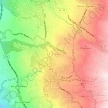
Name: L'Ermitage topographic map, elevation, terrain.
Location: L'Ermitage, Saint-Paul, La Réunion, 97435, France (-21.09347 55.25029 -21.05347 55.29029)
Average elevation: 1,476 ft
Minimum elevation: 381 ft
Maximum elevation: 2,343 ft
Make a donation
Gear up for your next adventure:
As an Amazon Associate, this site earns from qualifying purchases at no extra cost to you.
Other topographic maps
Click on a map to view its topography, its elevation and its terrain.
Ravine Saint-Gilles
France > La Réunion > Saint-Paul > Saint-Gilles-les-Hauts > Village de l'Éperon
Average elevation: 1,017 ft
Make a donation
Gear up for your next adventure:
As an Amazon Associate, this site earns from qualifying purchases at no extra cost to you.