
Strümpfelbach topographic map
Click on the map to display elevation.
About this map
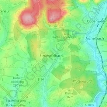
Name: Strümpfelbach topographic map, elevation, terrain.
Average elevation: 971 ft
Minimum elevation: 810 ft
Maximum elevation: 1,276 ft
Other topographic maps
Click on a map to view its topography, its elevation and its terrain.
Wildgehege Plattenwald
Deutschland > Baden-Württemberg > Rems-Murr-Kreis > Backnang > Strümpfelbach
Average elevation: 942 ft
Alter Hohlweg
Deutschland > Baden-Württemberg > Rems-Murr-Kreis > Backnang
Average elevation: 1,096 ft