
Make a donation
Gear up for your next adventure:
As an Amazon Associate, this site earns from qualifying purchases at no extra cost to you.
Gwadar topographic map
Click on the map to display elevation.
Make a donation
Gear up for your next adventure:
As an Amazon Associate, this site earns from qualifying purchases at no extra cost to you.
Gwadar
Gwadar is situated on the southwestern Arabian Sea coast of Pakistan in Gwadar District of Balochistan province. Like Ormara further east, Gwadar is situated on a natural hammerhead-shaped tombolo peninsula forming two almost perfect, but naturally curved, semicircular bays on either side. The city is situated on a narrow and sandy 12 km-long (7 mi) isthmus which connects the Pakistani coast to rocky outcroppings in the Arabian sea known as the Gwadar Promontory, or Koh-e-Batil, which reach an elevation of 150 m (480 ft) and extend 11 km (7 mi) east to west with a breadth of 1.5 km (1 mi). The 240 m (800 ft) wide isthmus upon which Gwadar is located separates the two almost perfect semicircular bays from one another. The western bay is known as the Paddi Zirr, and is generally shallow with an average depth of 3.7 m (12 ft), and a maximum depth of 9.1 m (30 ft). To the east of the isthmus is the deepwater Demi Zirr harbor, where the Gwadar Port was built.
Make a donation
Gear up for your next adventure:
As an Amazon Associate, this site earns from qualifying purchases at no extra cost to you.
About this map
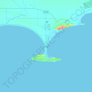
Name: Gwadar topographic map, elevation, terrain.
Location: Gwadar, Gwadar District, Balochistan, Pakistan (24.98798 62.16546 25.30798 62.48546)
Average elevation: 20 ft
Minimum elevation: -3 ft
Maximum elevation: 1,132 ft
Make a donation
Gear up for your next adventure:
As an Amazon Associate, this site earns from qualifying purchases at no extra cost to you.