
Make a donation
Gear up for your next adventure:
As an Amazon Associate, this site earns from qualifying purchases at no extra cost to you.
Infanta topographic map
Click on the map to display elevation.
Make a donation
Gear up for your next adventure:
As an Amazon Associate, this site earns from qualifying purchases at no extra cost to you.
About this map
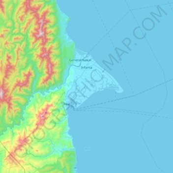
Name: Infanta topographic map, elevation, terrain.
Location: Infanta, Quezon, Calabarzon, 4336, Philippines (14.53426 121.43761 14.87463 121.83551)
Average elevation: 531 ft
Minimum elevation: -3 ft
Maximum elevation: 3,940 ft
Make a donation
Gear up for your next adventure:
As an Amazon Associate, this site earns from qualifying purchases at no extra cost to you.
Other topographic maps
Click on a map to view its topography, its elevation and its terrain.
Mount Labo
Philippines > Quezon > Tagkawayan
Labo is a forested andesitic stratovolcano, surrounded by numerous andesitic to dacitic satellite lava domes. It has an elevation of 1,544 metres (5,066 ft) asl. Base diameter of this complex volcano is 35 kilometres (22 mi). Labo is thermally active with both warm and hot springs.
Average elevation: 3,451 ft
Make a donation
Gear up for your next adventure:
As an Amazon Associate, this site earns from qualifying purchases at no extra cost to you.
Make a donation
Gear up for your next adventure:
As an Amazon Associate, this site earns from qualifying purchases at no extra cost to you.
Laguna & Quezon Provincial Highway Boundary
Philippines > Quezon > Dolores > San Cristobal
Average elevation: 499 ft
Make a donation
Gear up for your next adventure:
As an Amazon Associate, this site earns from qualifying purchases at no extra cost to you.
Make a donation
Gear up for your next adventure:
As an Amazon Associate, this site earns from qualifying purchases at no extra cost to you.
Make a donation
Gear up for your next adventure:
As an Amazon Associate, this site earns from qualifying purchases at no extra cost to you.