
Make a donation
Gear up for your next adventure:
As an Amazon Associate, this site earns from qualifying purchases at no extra cost to you.
Palakollu topographic map
Click on the map to display elevation.
Make a donation
Gear up for your next adventure:
As an Amazon Associate, this site earns from qualifying purchases at no extra cost to you.
Palakollu
At an average altitude of 1.5 metres (4.9 ft), Palakollu town is situated on National Highway 165 (India) and National Highway 216 (India). It is bounded by Krishna district and Vijayawada on the west, Amalapuram and Bay of Bengal on the east, Narasapuram and Bay of Bengal on the south, and Rajahmundry and East Godavari district on the north.
Make a donation
Gear up for your next adventure:
As an Amazon Associate, this site earns from qualifying purchases at no extra cost to you.
About this map
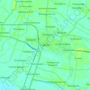
Name: Palakollu topographic map, elevation, terrain.
Average elevation: 23 ft
Minimum elevation: 7 ft
Maximum elevation: 39 ft
Make a donation
Gear up for your next adventure:
As an Amazon Associate, this site earns from qualifying purchases at no extra cost to you.