
Thank you for supporting this site ❤️
Make a donation
Make a donation
Gear up for your next adventure:
As an Amazon Associate, this site earns from qualifying purchases at no extra cost to you.
Tantarancha topographic map
Click on the map to display elevation.
Thank you for supporting this site ❤️
Make a donation
Make a donation
Gear up for your next adventure:
As an Amazon Associate, this site earns from qualifying purchases at no extra cost to you.
About this map
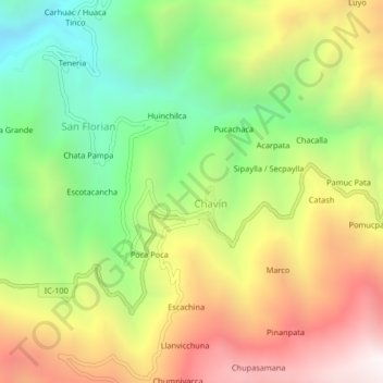
Name: Tantarancha topographic map, elevation, terrain.
Location: Tantarancha, San Florian, Chavín, Chincha, Ica, Perú (-13.09584 -75.93503 -13.05584 -75.89503)
Average elevation: 10,430 ft
Minimum elevation: 8,179 ft
Maximum elevation: 13,097 ft
Thank you for supporting this site ❤️
Make a donation
Make a donation
Gear up for your next adventure:
As an Amazon Associate, this site earns from qualifying purchases at no extra cost to you.