
Make a donation
Gear up for your next adventure:
As an Amazon Associate, this site earns from qualifying purchases at no extra cost to you.
Reykholt topographic map
Click on the map to display elevation.
Make a donation
Gear up for your next adventure:
As an Amazon Associate, this site earns from qualifying purchases at no extra cost to you.
About this map
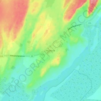
Name: Reykholt topographic map, elevation, terrain.
Location: Reykholt, Bláskógabyggð, Suðurland, Island (64.15834 -20.46613 64.19834 -20.42613)
Average elevation: 259 ft
Minimum elevation: 151 ft
Maximum elevation: 489 ft
Make a donation
Gear up for your next adventure:
As an Amazon Associate, this site earns from qualifying purchases at no extra cost to you.
Other topographic maps
Click on a map to view its topography, its elevation and its terrain.
Gullfoss
Der Wasserfall besteht aus zwei Stufen, von denen die erste 11 m und die zweite 21 m Höhe besitzt. Diese beiden Kaskaden stehen etwa rechtwinklig zueinander.
Average elevation: 702 ft