Geolocate

Cascade topographic map

Click on the map to display elevation.

About this map

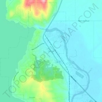
Name: Cascade topographic map, elevation, terrain.

Location: Cascade, Valley County, Idaho, 83611, USA (44.49599 -116.06184 44.53599 -116.02184)

Average elevation: 4,823 ft

Minimum elevation: 4,715 ft

Maximum elevation: 5,276 ft

Gear up for your next adventure:

Backpacking Tents - Weight-optimized shelters for multi-day topographic surveys
🕶️GPS Smartphone Mount - Secure mount for phone navigation
😴Insulated Sleeping Pads - Compact and warm pads for high-elevation camping
📡GPS Antenna Upgrade - Enhance GPS reception in remote terrain
👟Trail Running Shoes - Lightweight shoes for trail runners

As an Amazon Associate, this site earns from qualifying purchases at no extra cost to you.