
Merca District topographic map
Interactive map
Click on the map to display elevation.
About this map
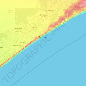
Name: Merca District topographic map, elevation, terrain.
Location: Merca District, Lower Shabelle, South West, Somalia (1.38574 44.38000 1.92002 45.22958)
Average elevation: 105 ft
Minimum elevation: 0 ft
Maximum elevation: 597 ft
Other topographic maps
Click on a map to view its topography, its elevation and its terrain.
Shaan
Somalia > Lower Shabelle > Afgooye District > Bulo-Yaqle
Shaan, Bulo-Yaqle, Afgooye District, Lower Shabelle, South West, Somalia
Average elevation: 253 ft
Degaybere
Somalia > Lower Shabelle > Qoriyoley District > Qoryooley
Degaybere, Halane, Qoryooley, Qoriyoley District, Lower Shabelle, South West, Somalia
Average elevation: 223 ft
Bulo Haji Maow
Somalia > Lower Shabelle > Afgooye District > Awgooye
Bulo Haji Maow, Awgooye, Afgooye District, Lower Shabelle, South West, Somalia
Average elevation: 289 ft
Nuria
Somalia > Lower Shabelle > Qoriyoley District > Qoryooley
Nuria, Qoryooley, Qoriyoley District, Lower Shabelle, Somalia
Average elevation: 226 ft
Wanlaweyn
Somalia > Lower Shabelle > Wanlaweyn District
Wanlaweyn, Wanlaweyn District, Lower Shabelle, South West, Somalia
Average elevation: 299 ft