

Mons topographic map
Click on the map to display elevation.
Mons
Situated at an altitude of 814 metres the commune of Mons encompasses a vast territory of 80 km2 (31 sq mi) in the Var, Provence, ranging from 214 metres (at the confluent of the Siagne and the Siagnole rivers) to 1715 metres at the summit of Mont-Lachens. This explains the variety of different scenery found on the territory of the commune, as well as the diversity of its vegetation, but also accounts for the fact that it is sparsely cultivated. There are exceptional views from the village (from the Place Saint Sebastien), ranging from Menton to the East all the way to Toulon in the West.
About this map
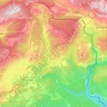
Name: Mons topographic map, elevation, terrain.
Average elevation: 3,068 ft
Minimum elevation: 587 ft
Maximum elevation: 5,591 ft
Other topographic maps
Click on a map to view its topography, its elevation and its terrain.

Berne
France > Provence-Alpes-Côte d'Azur > Var > Saint-Maximin-la-Sainte-Baume
Average elevation: 1,680 ft
Plage du Canon
France > Provence-Alpes-Côte d'Azur > Var > Saint-Mandrier-sur-Mer
Average elevation: 59 ft
Puget-sur-Argens
France > Provence-Alpes-Côte d'Azur > Var > Puget-sur-Argens > Puget-sur-Argens
Average elevation: 66 ft
Grotte des Tuves
France > Provence-Alpes-Côte d'Azur > Var > Saint-Cézaire-sur-Siagne
Average elevation: 1,188 ft