
Make a donation
Gear up for your next adventure:
As an Amazon Associate, this site earns from qualifying purchases at no extra cost to you.
Moheli topographic map
Click on the map to display elevation.
Make a donation
Gear up for your next adventure:
As an Amazon Associate, this site earns from qualifying purchases at no extra cost to you.
About this map
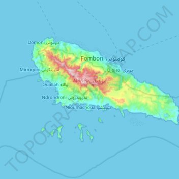
Name: Moheli topographic map, elevation, terrain.
Location: Moheli, Comoros (-12.42262 43.62239 -12.24892 43.92160)
Average elevation: 135 ft
Minimum elevation: 0 ft
Maximum elevation: 2,520 ft
Make a donation
Gear up for your next adventure:
As an Amazon Associate, this site earns from qualifying purchases at no extra cost to you.
Other topographic maps
Click on a map to view its topography, its elevation and its terrain.
Vanambouani فانامبواني
Comoros > Grande Comore > Itsandra-Hamanvou > Mbadani
Average elevation: 253 ft
Make a donation
Gear up for your next adventure:
As an Amazon Associate, this site earns from qualifying purchases at no extra cost to you.
Moroni
The country's civil aviation authority, Ministère des Postes et Télécommunications de la Promotion des Nouvelles Technologies de l'Information et de la Communication chargé des Transports et du Tourisme, is located in Moroni, as is the National Agency of Civil Aviation and Meteorology. Moroni is served by…
Average elevation: 1,152 ft