
Oscarville topographic map
Interactive map
Click on the map to display elevation.
About this map
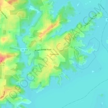
Name: Oscarville topographic map, elevation, terrain.
Location: Oscarville, Forsyth County, Georgia, United States (34.22843 -83.99491 34.26843 -83.95491)
Average elevation: 1,112 ft
Minimum elevation: 1,053 ft
Maximum elevation: 1,273 ft
Other topographic maps
Click on a map to view its topography, its elevation and its terrain.
Silver City
United States > Georgia > Forsyth County
Silver City, Forsyth County, Georgia, United States
Average elevation: 1,198 ft
Lake Lanier
United States > Georgia > Forsyth County > Cumming
Lake Lanier, Cumming, Forsyth County, Georgia, 30506, United States
Average elevation: 1,152 ft
Chestatee
United States > Georgia > Forsyth County
Chestatee, Forsyth County, Georgia, United States
Average elevation: 1,237 ft
Coal Mountain
United States > Georgia > Forsyth County
Coal Mountain, Forsyth County, Georgia, 30028, United States
Average elevation: 1,207 ft
Cumming
United States > Georgia > Forsyth County
Cumming, Forsyth County, Georgia, United States
Average elevation: 1,198 ft
Hightower
United States > Georgia > Forsyth County
Hightower, Forsyth County, Georgia, United States
Average elevation: 1,066 ft