
Chestatee topographic map
Click on the map to display elevation.
About this map
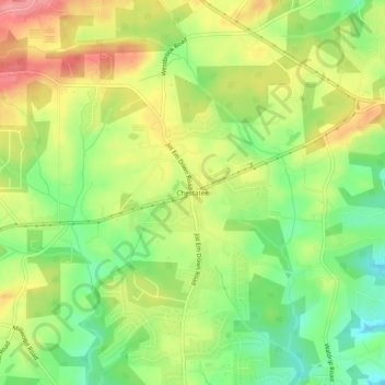
Name: Chestatee topographic map, elevation, terrain.
Location: Chestatee, Forsyth County, Georgia, United States (34.27427 -84.01963 34.31427 -83.97963)
Average elevation: 1,237 ft
Minimum elevation: 1,073 ft
Maximum elevation: 1,417 ft
Forsyth County trails, hiking, mountain biking, running and outdoor activities
Other topographic maps
Click on a map to view its topography, its elevation and its terrain.
Chattahoochee River National Recreation Area
United States > Georgia > Forsyth County > Atlanta
Average elevation: 1,037 ft
Lake Lanier
United States > Georgia > Forsyth County > Cumming
According to the Army Corps of Engineers, the Dam has a current installed capacity of 126 megawatts and a hydraulic head of 136 feet. Other pertinent information on the reservoir, power plant, etc. can be found on the Mobile District Corps of Engineers web site. Also, historic operational information on lake…
Average elevation: 1,152 ft