
Dalaba Prefecture topographic map
Interactive map
Click on the map to display elevation.
About this map
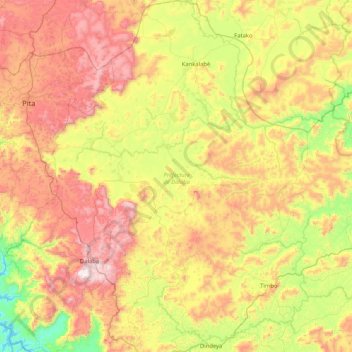
Name: Dalaba Prefecture topographic map, elevation, terrain.
Location: Dalaba Prefecture, Mamou Region, Guinea (10.47887 -12.50502 11.29452 -11.73597)
Average elevation: 2,625 ft
Minimum elevation: 1,125 ft
Maximum elevation: 4,639 ft
Other topographic maps
Click on a map to view its topography, its elevation and its terrain.
Pita Prefecture
Pita Prefecture, Mamou Region, Guinea
Average elevation: 2,142 ft
Pita
Guinea > Mamou Region > Pita Prefecture
Pita, Pita Prefecture, Mamou Region, Guinea
Average elevation: 3,074 ft