
Pita Prefecture topographic map
Interactive map
Click on the map to display elevation.
About this map
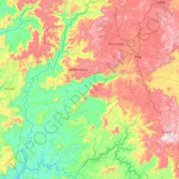
Name: Pita Prefecture topographic map, elevation, terrain.
Location: Pita Prefecture, Mamou Region, Guinea (10.46327 -12.97428 11.33309 -12.19301)
Average elevation: 2,142 ft
Minimum elevation: 581 ft
Maximum elevation: 4,639 ft
Other topographic maps
Click on a map to view its topography, its elevation and its terrain.
Dalaba Prefecture
Dalaba Prefecture, Mamou Region, Guinea
Average elevation: 2,625 ft
Pita
Guinea > Mamou Region > Pita Prefecture
Pita, Pita Prefecture, Mamou Region, Guinea
Average elevation: 3,074 ft