
Thank you for supporting this site ❤️
Make a donation
Make a donation
Gear up for your next adventure:
As an Amazon Associate, this site earns from qualifying purchases at no extra cost to you.
Włodawa topographic map
Click on the map to display elevation.
Thank you for supporting this site ❤️
Make a donation
Make a donation
Gear up for your next adventure:
As an Amazon Associate, this site earns from qualifying purchases at no extra cost to you.
About this map
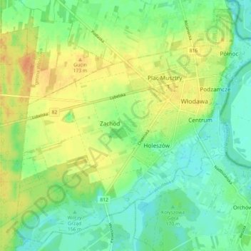
Name: Włodawa topographic map, elevation, terrain.
Location: Włodawa, Włodawa County, Lublin Voivodeship, 22-200, Poland (51.51552 23.48950 51.56708 23.57810)
Average elevation: 545 ft
Minimum elevation: 495 ft
Maximum elevation: 604 ft
Thank you for supporting this site ❤️
Make a donation
Make a donation
Gear up for your next adventure:
As an Amazon Associate, this site earns from qualifying purchases at no extra cost to you.